Understanding the Sun, our closest star, is essential for both scientific research and practical applications on Earth. The GOES-16 satellite, part of the Geostationary Operational Environmental Satellite system, has provided high-resolution images of the Sun that are transforming our knowledge of solar activity, space weather, and the Sun-Earth connection. These images allow scientists to observe solar phenomena in unprecedented detail, helping to predict solar storms, understand the dynamics of the Sun’s atmosphere, and safeguard technology and infrastructure on Earth.
What is the GOES-16 Satellite?
Launched on November 19, 2016, GOES-16 (originally called GOES-R) is a next-generation geostationary weather satellite operated by NOAA (National Oceanic and Atmospheric Administration) in partnership with NASA. It orbits Earth at a fixed point above the equator, about 22,300 miles (35,786 km) from the surface, allowing it to continuously monitor the Western Hemisphere, including the Sun-facing side of the planet.
Key Features of GOES-16:
-
Advanced Baseline Imager (ABI): Captures high-resolution images of the Earth and Sun in multiple wavelengths.
-
Space Weather Instruments: Monitors solar activity, energetic particles, and geomagnetic conditions.
-
Geostationary Orbit: Provides constant observation, allowing continuous monitoring of the Sun and Earth systems.
GOES-16 represents a significant technological leap over previous satellites, offering sharper images, faster data collection, and broader coverage of solar phenomena.
Why Observe the Sun?
The Sun is a dynamic star whose activity directly affects Earth and its technological systems. Observing the Sun is essential for several reasons:
-
Predicting Space Weather: Solar flares, coronal mass ejections (CMEs), and energetic particles can disrupt satellites, GPS systems, power grids, and communication networks.
-
Protecting Astronauts and Spacecraft: Solar radiation poses significant risks to astronauts and spacecraft, especially during solar storms.
-
Understanding Solar Physics: Studying solar phenomena helps scientists comprehend fundamental processes, such as magnetic field interactions and energy transfer in the Sun’s atmosphere.
-
Climate and Atmospheric Studies: Solar activity influences Earth’s upper atmosphere and can affect weather patterns and climate over time.
The GOES-16 satellite provides real-time, high-resolution imagery that is critical for monitoring and predicting these solar effects.
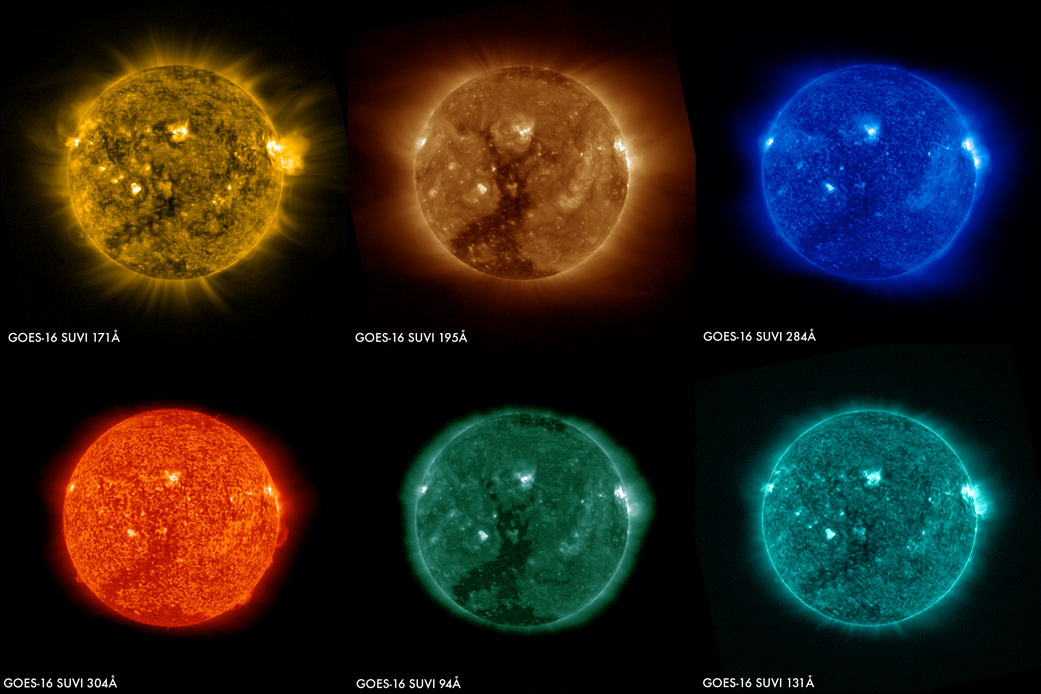
GOES-16 Solar Imaging Capabilities
GOES-16 is equipped with instruments capable of capturing the Sun’s activity in multiple wavelengths, particularly in the ultraviolet (UV) and extreme ultraviolet (EUV) ranges. These wavelengths reveal details invisible in visible light, including:
-
Solar Flares: Sudden bursts of radiation from the Sun’s surface.
-
Coronal Mass Ejections (CMEs): Massive bursts of solar plasma that can impact Earth’s magnetosphere.
-
Sunspots and Active Regions: Areas of intense magnetic activity.
-
Coronal Holes: Regions with open magnetic field lines that emit high-speed solar wind.
The ABI instrument captures images at a resolution of 0.5 to 2 kilometers per pixel, allowing scientists to observe fine details in the Sun’s corona and active regions. Images are updated every 10 to 15 minutes, providing near-real-time monitoring of solar events.
Key Solar Phenomena Captured by GOES-16
1. Solar Flares
Solar flares are sudden, intense bursts of radiation from the Sun’s atmosphere. GOES-16 captures flares in high-resolution EUV imagery, allowing scientists to:
-
Track flare intensity and duration.
-
Analyze the release of energy and particles.
-
Improve space weather forecasting to protect satellites and power grids.
By observing flares in multiple wavelengths, researchers can study how energy propagates through the Sun’s atmosphere.
2. Coronal Mass Ejections (CMEs)
CMEs are huge explosions of solar plasma and magnetic fields that travel through space. GOES-16 images help detect and track these ejections as they leave the Sun. Key benefits include:
-
Predicting the arrival of CMEs at Earth.
-
Estimating the potential impact on satellites, power systems, and communications.
-
Studying the interaction between CMEs and the solar magnetic field.
These observations are crucial for minimizing the risk posed by severe space weather events.
3. Sunspots
Sunspots are dark, cooler regions on the Sun’s surface associated with intense magnetic activity. GOES-16 captures sunspots with remarkable clarity, allowing scientists to:
-
Monitor solar cycles, which influence solar activity over time.
-
Predict periods of high solar activity that may increase space weather risks.
-
Study the magnetic structure and evolution of sunspot regions.
4. Coronal Holes
Coronal holes are areas where the Sun’s magnetic field is open to space, allowing high-speed solar wind to escape. GOES-16 images help identify these regions, which is important for:
-
Forecasting geomagnetic storms.
-
Understanding solar wind patterns and their effects on Earth.
-
Studying long-term variations in the Sun’s magnetic activity.
Applications of GOES-16 Solar Imagery
The high-resolution solar images from GOES-16 serve multiple scientific, operational, and public safety purposes:
Space Weather Forecasting
Real-time solar imagery allows meteorologists and space weather forecasters to:
-
Track solar flares and CMEs as they occur.
-
Predict geomagnetic storms that could affect Earth.
-
Issue warnings to satellite operators, power companies, and aviation sectors.
Satellite and Communication Protection
Solar storms can interfere with satellites and communication systems. GOES-16 imagery provides:
-
Early warnings for satellite operators to adjust or shut down vulnerable systems.
-
Alerts for airlines to modify flight paths to avoid increased radiation exposure at high altitudes.
Research and Education
-
Solar scientists use GOES-16 data to study coronal dynamics and magnetic field interactions.
-
Educational programs utilize the imagery to teach students about solar physics and space weather.
Climate and Atmospheric Studies
-
Solar irradiance data contributes to models of Earth’s upper atmosphere and climate systems.
-
Observing solar activity helps scientists understand long-term effects on Earth’s weather and climate.
Visualization and Public Access
GOES-16 solar images are not only valuable to scientists but also accessible to the public:
-
NOAA’s Satellite and Information Service provides interactive tools to view solar imagery in near-real-time.
-
NASA’s Space Weather Prediction Center publishes daily updates on solar activity.
-
High-resolution imagery is used in educational programs, documentaries, and research publications.
These resources allow everyone, from students to space enthusiasts, to explore and understand the dynamic nature of our Sun.
Recent Discoveries from GOES-16 Imagery
Since its launch, GOES-16 has enabled several notable discoveries and observations:
-
Detailed Flare Dynamics: Scientists observed the rapid development and propagation of solar flares, refining models of energy release in the corona.
-
CME Tracking Improvements: GOES-16 imagery allows faster and more precise predictions of CME paths and potential impacts on Earth.
-
Sunspot Cycle Monitoring: Continuous observation has provided valuable insights into the progression of solar cycle 25.
-
Coronal Wave Studies: High-resolution imaging captured waves propagating through the corona, shedding light on coronal heating mechanisms.
These findings contribute to our understanding of solar physics and help prepare for potential space weather hazards.
Future Prospects
GOES-16 is the first in a new series of advanced geostationary satellites. Future prospects include:
-
Integration with GOES-17 and GOES-T: Creating a network of satellites for continuous solar and weather monitoring.
-
Enhanced Space Weather Prediction: Combining solar imagery with magnetospheric and ionospheric data to improve forecasts.
-
Long-Term Solar Studies: GOES-16’s continuous observation helps track solar activity over decades, contributing to climate studies and solar cycle research.
The satellite’s data will continue to benefit both scientific research and practical applications on Earth for years to come.
Conclusion
The GOES-16 satellite has transformed our ability to observe the Sun, providing high-resolution images that reveal the intricate dynamics of solar flares, coronal mass ejections, sunspots, and coronal holes. These observations are crucial for predicting space weather, protecting technology, advancing solar physics research, and educating the public.
By combining cutting-edge imaging technology, real-time data access, and collaboration between NASA and NOAA, GOES-16 has become an indispensable tool in understanding our closest star. Its imagery not only enhances our scientific knowledge but also strengthens our ability to prepare for the Sun’s influence on Earth. As solar activity continues to evolve, GOES-16 will remain a vital sentinel, watching the Sun and helping humanity navigate the challenges and wonders of space weather.
Read Also: Keep your face towards the sunshine and shadows will fall behind you
Watch Also: https://www.youtube.com/@TravelsofTheWorld24


Leave a Reply